
Investigating Land Use Change
Students will use remotely sensed images to recognize land use patterns of diverse areas in our world. They will also examine and interpret time-sequenced satellite data and aerial photographs of urban areas to interpret geographic growth patterns. In addition, they will examine landscape changes over time through analysis and interpretation of satellite data images and aerial photographs.
- Ask students how some feature in their neighborhood or city has changed over time. If students have difficulty, prompt them with the following examples: the development of a newly created park area, the building of a new shopping mall, a new school or sports arena. Ask students how that change might look on a satellite image before and after the feature was constructed.
- Tell students they will be looking at a series of satellite image pairs to examine land use change over time. Have students view the Land Use Change Images Web site or handout. Tell students that each site highlights different landscape changes over time.
- Distribute the handout, Land Use Change to each student. Have students complete Part 1: Making Predictions for each image pair.
- Next, have students read the "Background information review" in Part 2 of the handout. Review with students some of the key color features used in false color satellite images for identifying features:
What might a red color indicate? (Growth of vegetation, forests, grass, lawns and trees in established neighborhoods).What might a black color indicate? (A water body such as a lake, ocean, or river).What might a green color indicate? (Agricultural fields or bare soils).
- Instruct students to complete the Land Use Change Investigation Sheet. Remind students to look at the tone, size, shape, texture, pattern, shadow, site, and association elements in the satellite image to help them with their interpretations.
- Review student responses as a class. Use the satellite images on the Land Use Change Images Web site or handout to point out key land use change features. Refer to the Land Use Change – Explanation Guide.
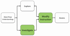
- Certain populations of students have much difficulty interpreting remotely sensed images in environmental contexts that are unfamiliar to them. Much scaffolding and highly structured questions may be needed to guide students to observe spatial patterns in time-sequenced images that are associated with observing land use change over time in diverse geographical locations. If needed, modify instruction to model the processes of analyzing and interpreting these images to your students.
- Prior to discussing question 18, introduce the term "sprawl" to students. Sprawl is defined as the process in which the spread of development across the landscape far outpaces population growth. In discussing student responses to question 18, emphasize the importance of "smart growth" practices that takes advantage of wise resource use including: encouraging compact building development and discouraging dispersed, automobile dependent development at the urban fringe; taking advantage of existing structures such as reusing abandoned industrial sites (brownfield development; building along rail lines and public transportation routes; and creating highly connected roads, sidewalks and paths, allowing relatively direct travel by motorized and nonmotorized modes. Note to students that satellite images can be used to identify landscape provisions for smart growth practices in rapidly growing cities.
Materials Needed:
Assessment Information
Land Use Change Assessment (PDF / MS Word)
Supplemental Homework Readings for Students
Land Cover Change (PDF)
Analyzing Land Use Change In Urban Environments (PDF)
Teacher Resource