
Atlanta Case Study Investigation
Students will interpret land use maps of the greater Atlanta area to understand environmental issues that are typically associated with sprawl.
- Distribute the handout, Atlanta Case Study to each student. Instruct students to read the opening paragraph of Part 2: Using Land Use Maps to Examine Sprawl. Have students complete questions #1-3. Discuss the answers when finished.
- Display the Atlanta Case Study: Land Use Classification Maps. These maps show the land use for the metropolitan Atlanta area for the years 1973, 1983, 1992, and 1997. Review the key with the students. Forested areas are green, farmland areas are yellow and water is blue. Red and orange points indicate areas of population densities. Instruct students to complete questions #4-7.
- Instruct students to open the Atlanta Area.kml file in Google Earth. Display the image in front of the classroom. Show students how to turn on the road layer. Explain to students that this is the greater metropolitan area of Atlanta. Show students how to use the Ruler tool to measure distances in a straight line and for a path for Interstate 285. Instruct students to identify the locations of the interstate highways in and around the city, explore the land uses around these interstates, and complete questions #8-9.
- Review student answers in a whole class setting for Part 2: Using Land Use Maps to Examine Sprawl. Display the Atlanta Case Study: Land Use Classification Maps in the front of the class and point out observable data patterns to students to reinforce image data interpretation and land use change patterns over time.
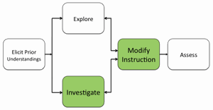
- If students at the completion of this investigation still have difficulty interpreting land use classification maps to identify patterns typically associated with sprawl, modify instruction to ensure students acquire this spatial analysis skill.
Materials Needed:
Atlanta Case Study: Land Use Classification Maps Web site or handout (PDF / MS Word)
Google Earth file:
Assessment Information:
Atlanta Case Study Assessment (PDF / MS Word)
Supplemental Homework Readings for Students
Keeping New York City "Cool" is the Job of NASA's "Heat Seekers" (PDF)