Mystery Landsat Images
Students will understand how satellites use remote sensing to produce images. Students will recognize that the earth's surface has different basic land surfaces that reflect/emit different radiation. Students will identify and interpret features on Landsat images.

- Display the mystery image of the strawberry from the Lehigh Earth System Science Education Remote Sensing Web site - http://www.ei.lehigh.edu/esse/rs/ to the front of the classroom. Use this Flash animation to introduce remote sensing as measuring or gathering information about an object or a phenomenon without having physical contact with the object. Continue to show the next Web page, http://www.ei.lehigh.edu/esse/rs/?p=2 to highlight the use of a dental x-ray as another example of a remote sensing technique.
- Continue to the next screen http://www.ei.lehigh.edu/esse/rs/?p=3 to tell students that remote sensing instrumentation is housed on satellites in orbit around the Earth and are used by many different scientists to explore and understand the Earth.
- Continue to http://www.ei.lehigh.edu/esse/rs/?p=5. Tell students that objects on Earth reflect, absorb, and emit electromagnetic radiation at unique wavelengths and frequencies. The electromagnetic radiation travels in waves across great distances. Different objects have different physical characteristics so they reflect or emit energy differently. Explain to students that the image on the right is a true color photo of Death Valley, California. The image on the left is a false color satellite image of that area. The colors appear different in the false color image due to the different energy being reflected from the ground features.
- Show the animation at http://www.ei.lehigh.edu/esse/rs/?p=6 to students. Review each step of the process of remote sensing with the students.
- Show the images of Landsat 7, MODIS, and AVHRR at http://www.ei.lehigh.edu/esse/rs/?p=10 to students. Explain that these satellite instruments monitor our earth's atmosphere and also record data on the Earth's surface that is used by scientists to monitor changes over time.
- Show the complete animation sequence at http://www.ei.lehigh.edu/esse/rs/?p=11 to students. Highlight the key features involved with image generation.
- Show the clickable image sequence at http://www.ei.lehigh.edu/esse/rs/?p=12 to show students that scientists used remotely sensed images to classify different land use types.
- Display Mystery Image 1 from the Landsat Mystery Image Pairs Web site (or handout). Tell students they are looking at a pair of remotely sensed images taken from the Landsat 1 satellite. The Landsat image pairs are provided in two formats: a natural-color composite image taken with Thematic Mapper bands 3, 2 and 1 and a false-color composite image 4, 3 and 2. Tell students they will be learning how to use these types of remote sensing image pairs to analyze and interpret remotely sensed images taken from the Landsat satellite.
- Distribute the Mystery Landsat Images Exploration Sheet to each student. Instruct students to look at each mystery image pair and predict what type of area they think each image represents. Have students record their predictions on the handout.
- Have students read the description of natural-color composite images on Part 2. Instruct students to examine the natural-color Landsat mystery images and complete Part 2 of the handout. Review student responses as a class.
- Have students read the description of false-color composite images on Part 3. Instruct students to examine the false-color Landsat mystery images and complete Part 3 of the handout. Review student responses as a class.
- Instruct students to complete the analysis questions in Part 4. Review student responses as a class.
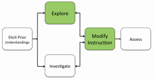
- If students at the completion of this activity still have difficulty interpreting false-color composite image representations, modify instruction to ensure students acquire this spatial analysis skill.
Materials Needed:
Assessment Information
Mystery Landsat Images Assessment (PDF / MS Word)
Supplemental Homework Readings for Students
Land Cover Classification (PDF)
Landsat: A Global Land-Observing Program (PDF)
How Landsat images are made (PDF)
