Land Use Around the Mall
Students will examine the land use around a mall area. They will investigate human-built and natural features in the area surrounding the Madison Square Mall in Huntsville, Alabama.

Helpful implementation idea:
Prior to class, be sure that the Google Earth application is ready to use on students' computers. It is important to test out the KML file on each computer to ensure that students will be able to view the coverage area. Often, classroom computers may use Google Earth for other investigations that involve layers that cover other "checked" layers. These "covering" layers should be deleted or unchecked prior using the Land Use Change files to minimize potential issues that may occur with students viewing the Land Use Change curricular files.
- Distribute the handout: Let's Go to the Mall! to each student.
- Instruct students to open the Madison Square Mall Area.kml in Google Earth. Display the image in front of the classroom. Ask students to identify the feature that is most likely a mall. Tell students to look for human-built features and natural features in the Madison Square Mall area. Have them record their observations on the handout.
Helpful implementation idea:
Show students that when they download a KML file from the Internet, it is placed on to their computer's desktop and the Google Earth application will launch automatically. Google Earth will add the file name as a layer in the "Temporary Places" folder in the Places window. See image below. Show students that if they zoom-in or pan around the viewer window and get lost, they can double click on the file name in the Places window to return to the original location.
- Have students use Google Earth to identify the 14 features noted on the handout. Tell students they might need to zoom-in closely to identify each feature.
- After students have completed their feature identifications, review the identity of each feature with Google Earth at the front of the classroom. Have students articulate visual evidence to support their identification claims. When possible, prompt students to identify differences with respect to tone, size, texture, pattern, shadow, site, and association in the image.
Helpful implementation idea:
Note that lower-level learners or classes with large numbers of students with disabilities might need additional modeling and scaffolding with hints and prompts to identify features. Going through each feature identification one at a time with these students, using prompts to highlight specific image features with a projected computer image is an effective instructional strategy.
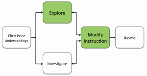
- If students at the completion of the activity still have difficulty examining visual evidence with respect to tone, size, texture, pattern, shadow, site, and association, modify instruction to ensure students understand how to use these spatial analysis skills.
Materials Needed:
Handout
Let's Go to the Mall! – (Mall Activity 1) (PDF / MS Word) (one copy of each per student)
Google Earth File
Assessment Information
Let's Go to the Mall! – (Mall Activity 1) Assessment (PDF / MS Word)
