Where is the Best Place to Locate a Geothermal Power Plant?
1. Begin the class by asking students to respond to the following question in their journal: What is geothermal energy?
2. Inform students that they will learn about geothermal energy.
3. Use an LCD to display the "Hot Earth" video clip. This is a series of Iceland hotspots that include hot spots near power plants in Iceland, the Blue lagoon, bubbling mud, fumaroles, an active volcano area, and a geyser area.
4. Introduce students to concepts related to geothermal energy. Highlight the two main applications of geothermal energy, ambient ground heat and hot Earth spots (areas with high geothermal gradients. Discuss geothermal energy uses from ambient warm ground sources. Emphasize the geological limitations of geothermal energy use.
5. Distribute the Where is the Best Place to Locate a Geothermal Power Plant? handout and field guide to each student.
6. Use an LCD projector to display Google Earth at the front of the room.
7. Ask students to launch Google Earth on their computers.
8. Instruct students to download the Hot Earth Areas KML file and view the file in Google Earth. Model how to turn the red overlays off.
9. Illustrate how to describe the features of geothermal areas. Have students investigate where the earth is hot and complete the data chart on their field guides. Provide guidance.
Helpful hint: Tell students they can use the navigation controls at the top right of the screen to explore features in more detail.
10. Instruct students to download the Metropolitan Areas KML file and view the file in Google Earth. Provide guidance. Have students answer questions on their field guides.
11. Review and discuss aloud student responses to key questions. Ask students if they have any questions about concepts covered in the lesson and respond to their questions. Have students close and not save Google Earth when they finish.
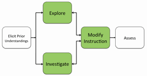
12. If students at the completion of the activity do not understand that hot Earth areas are needed to locate a geothermal power plant, modify instruction to ensure students understand this concept.
Materials Needed:
Video
Hot Earth Video Clip (QuickTime video)
Handouts
(1) Where is the Best Place to Locate a Geothermal Power Plant? Teacher Guide (PDF / MS Word)
(2) Where is the Best Place to Locate a Geothermal Power Plant? Student Handout (PDF / MS Word)
(3) Where is the Best Place to Locate a Geothermal Power Plant? Field Guide (PDF / MS Word)
KML Files
(1) Hot Earth Areas (KML)
(2) Metropolitan Areas (KML)
Assessment Information
Exploring Hot Earth Areas with Google Earth Assessment (PDF / MS Word)
Supplemental Homework Readings for Students
Geothermal Energy (PDF)
Teacher Resources/Content Support
Geothermal Energy - Print Version (PDF)
Google Earth Geothermal Tutorial (QuickTime Video)