Investigation 6: What happens when plates collide?
In this activity, students will use the distribution of earthquakes and volcanoes in a Web GIS to learn about plate collision at an ocean-ocean subduction zone, and ocean-continent subduction zone. They will also recreate a continent collision to learn about convergent zones. They will:
- Discover the relationship between the subduction zones and volcanoes.
- Determine the slope of subduction along a convergent plate boundary.
- Learn the types of landforms created by continents colliding at convergent zones.
Important Notes:
- Prior to implementing this learning activity, make sure that students have some prerequisite knowledge about the different types of convergent boundaries (ocean-ocean, ocean-continent, continent-continent) and subduction. It is helpful if students have some knowledge about the formation of geologic features (for example mountains, trenches, island arcs) that form at convergent boundaries. These concepts are explored in more detail in this investigation.
- We recommend that you read the What happens when plates collide? Teacher Guide prior to implementing this investigation. The Teacher Guide contains additional content and pedagogical support materials that are not described on this Web page.
Note: A video overview of the learning activity is located below in the Teacher Resources/Content Support section of this Web page. This overview shows how to use the GIS for data analysis in the investigation. A second video provides an overview of the Web GIS interface and navigation features. You may wish to show your students these videos as you introduce the learning activity.
Suggested Sequence:
1. Begin the class by asking students to respond to the following in their journals: What happens when plates run into each other?
2. Inform students that they will learn to use a GIS to learn about plate collision and subduction using earthquake, volcano, and landform data and imagery.
3. Use an LCD projector to display the Web GIS to the front of the room. The Web GIS will open to a global view with the Enhanced Bathymetry/Topography layer turned on displaying a blue investigation box on the GIS around the Aleutian Islands study area.
4. Distribute the What happens when plates collide? Student Guide and Investigation Sheet to each student. Instruct students to follow the directions outlined in their guides.
5. Instruct students to go to: /learners/tectonics and click on What happens when plates collide?
6. If needed, provide an orientation of the Web GIS layout and tool features to your students. We recommend that you show students how to use the Map Layers tab to activate and deactivate layers and how to use the Map Legend tab to interpret the data layers.
7. Model how to use the Navigation Tools tab to zoom the map into the first study area, the Aleutian Islands. It may be helpful to help students orient themselves with where the Aleutian Islands are located by prompting students to identify which ocean, which part of the ocean, and which U.S. state the study area includes.
8. Have students begin the investigation, complete all data charts and answer the questions on their investigation sheets. Provide guidance to students as needed.
9. In Step 2, students will trace the plate boundary using the Draw Tools and identify the names of the plates subducting and overriding at the Aleutian Trench. To identify a plate name, click on the GIS map. When they click on a location, a box will appear with that location’s plate name. For example, when they click on North America, a box that says “Plate Name: North American Plate” will appear. Double-clicking will cause the map to zoom in.
Implementation suggestion:
- Before you begin Step 2, we recommend that you explicitly model to your students how to interpret an elevation profile graph from a profile line drawn on the GIS. Some students may need additional support understanding that all elevations below sea level will be negative numbers, while elevations above sea level will be positive numbers. Sea level is at 0 meters elevation. A deeper sea floor elevation corresponds to a higher negative number. A shallower sea floor elevation corresponds to a lower negative number.
10. Students will watch a video on plate subduction at the Aleutian Trench. The video shows a subduction zone where ocean crust is subducting underneath lithospheric crust. The downgoing slab at the subduction zone heats up and partially melts causing magma to rise up through the overriding plate resulting in the formation of volcanoes. This heat rises through the surface going through the overarching plate and results in the formation of volcanoes.
Implementation Suggestion:
- We recommend that you display the video to the front of the room and explicitly describe the tectonics processes that are described above.
11. In Step 3 students will use the Subduction Zone Profile tab to investigate the subducting slab at two locations along the subduction zone. Make sure students understand the legend in the Subduction Zone Profile tab.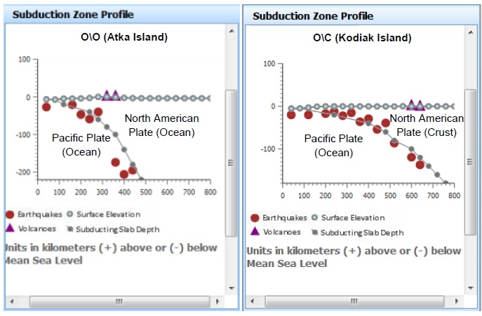
12. Students will use the Distance Measure Tool in the Measure Tools tab to measure the distance of volcanoes to the plate boundary.
Implementation Suggestion:
- Some students may require explicit modeling in order to interpret the subduction zone profiles. We suggest that you use guiding questions to note the locations of the volcanoes, the deepest earthquakes, and prompts to help students identify which plate is the subducting plate (Pacific Plate) and which plate is the overriding plate (North American Plate).
13. In Part 2, students will explore the landforms created by volcanoes at different subduction zones in the Aleutian Islands and the Northwestern United States.
Implementation Suggestion:
- It may be helpful to remind students to think about which types of plate boundaries form different types of geologic hazards. Volcanoes are formed on the overriding plate at a convergent boundary, as seen in the Northern Pacific U.S. Volcanoes do not occur on transform plates, as seen in the Southern Pacific U.S.
14. In Step 5 students will explore what happens when continent collide. Students will virtually collide the North America and Africa continent boundaries using the Continent Boundaries tab. The Elevation Profile tab will be used to identify the types of surface landforms these continent collisions create.
Implementation Suggestion:
- We recommend that you model how to use the Continent Boundaries tool to select, move, and rotate the continents on the GIS.
- For classes with students with special needs, you may wish to provide additional modeling, prompts and guidance as students work through the investigation. You may wish to explicitly model each procedural step with the Web GIS using a projected image before the students work independently or in pairs to complete the learning tasks.
15. Review and discuss aloud student responses to key questions on their Investigation Sheets. Ask students if they have any questions about concepts covered in the lesson and respond to their questions.
16. If students at the completion of the activity do not understand the relationship between subduction zones and volcano formation or how different landforms are created by continents colliding at convergent zones, modify instruction as needed to ensure students understand these concepts.
17. To provide closure to this investigation, have students reflect on what they have learned about tectonic plate collisions and discuss.
Here are some suggestions: Provide students with a reflective question to respond in their journals about plate collisions. For example:
a) What happens when tectonic plates collide?
b) What types of landforms are created by continents colliding at convergent zones?
Materials Needed:
Handouts
(1) What happens when plates collide? Teacher Guide (PDF / MS Word)
(2) What happens when plates collide? Student Guide (PDF / MS Word)
(3) What happens when plates collide? Investigation Sheet (PDF / MS Word)
Web GIS
http://gisweb.cc.lehigh.edu/tectonics/investigation6/
Assessment Information
What happens when plates collide? Assessment (PDF / MS Word)
PowerPoint File
Examples of Fault Types (PPT)
Teacher Resources/Content Support
Geologic Faults - Print Version (PDF)
Web GIS Investigation 6 Tutorial (QuickTime Video)
Web GIS Features Overview (QuickTime Video)