Exploring Water Bodies with Google Earth

1. Begin the class by asking students to respond to the following question in their journal: What is tidal energy?
2. To gain attention, ask students whether they surf when they go to the beach.
3. Inform students that they will learn about tidal energy and examine different water bodies to determine whether they are good locations for tidal power plants.
4. Ask students what they know about tidal energy. Ask students to go to the student resources Web page and click on the About Tidal Energy link.
5. Instruct students to read the tidal energy Web pages. Clarify key terms and explain tidal concepts as needed.
6. Distribute the Exploring Water Bodies with Google Earth handout and field guide to each student.
7. Use an LCD projector to display Google Earth at the front of the room.
8. Ask students to launch Google Earth on their computers.
9. Instruct students to download the Water Bodies KML file and view the file in Google Earth.
10. Display the Bay of Fundy in Google Earth at the front of the room. Describe the shape of the bay and emphasize that it is funnel shaped, thus, a good location for a tidal power plant. Show students how to read the information about the Bay of Fundy.
11. Have students examine the Bay of Fundy, the Bay of Severn, the Baltic Sea, and the Gulf of Mexico. Instruct students to read information about these water bodies, analyze their shapes, and answer questions on their field guides.
Implementation Suggestion:
- For certain populations of learners, you may wish to have students draw the shape of the water body on the Water Bodies Data Chart. You may need to expand the size of the data chart rows to accommodate student drawings.
12. Provide guidance as students do the activity.
13. Review and discuss aloud student responses to key questions. Ask students if they have any questions about concepts covered in the lesson and respond to their questions. Have students close and not save Google Earth when they finish.
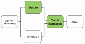
14. If students at the completion of the activity do not understand that areas with high tidal ranges have funnel-like shapes or forced into a narrow channel, modify instruction to ensure students understand this concept.
Materials Needed:
Handouts
(1) Exploring Water Bodies with Google Earth Teacher Guide (PDF / MS Word)
(2) Exploring Water Bodies with Google Earth Student Handout (PDF / MS Word)
(3) Exploring Water Bodies with Google Earth Field Guide (PDF / MS Word)
KML File
Water Bodies (KML)
Assessment Information
Exploring Water Bodies with Google Earth Assessment (PDF / MS Word)
Supplemental Homework Readings for Students
Ocean Energy (PDF)
Teacher Resources/Content Support
Tidal Energy - Print Version (PDF)
Google Earth Tidal Tutorial (QuickTime Video)
