Exploring Hydroelectric Dams with Google Earth.

1. Begin the class by asking students to write in their journals the names of any two dams in the USA.
2. Inform students that they will use Google Earth to explore hydroelectric dams around the world.
3. Distribute the Exploring Hydroelectric Dams with Google Earth handout and field guide to each student.
4. Use an LCD projector to display Google Earth to the front of the room.
5. Ask students to launch Google Earth on their computers.
6. Instruct students to download the Hydroelectric dams KML file and view the file in Google Earth.
7. Show students how to navigate from one dam to the next.
8. Model how to use the Ruler Tool in Google Earth to measure the width and distance of the first dam (Hoover) to the nearby population center.
NOTE: We recommend that you explain to students how they should measure the width of the dams. For example, have students measure the upstream side of the dam at the widest part or across the dam structure. The assessment information takes into account these variations. Point out that dark area is water.
9. Have students repeat this task on their computers. Have students measure the dam width and distance of each dam to nearby population center. Provide guidance as students do the activity.
10. Ask students to answer questions on their field guides.
Helpful hint 1: Students will need to zoom in or out to view a population center near the dam. Have students look for the nearest population center that is marked in the Google Earth 3D viewer with a small red circle.
Helpful hint 2: Some dams have more than one water release gate. Instruct students to measure each one and add the segments together to determine the width of the dam.
11. Review and discuss aloud student responses to key questions. Ask students if they have any questions about concepts covered in the lesson and respond to their questions. Have students close and not save Google Earth when they finish.
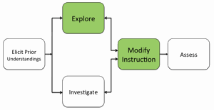
12. At the completion of the activity, if students do not observe that most dams have a large upstream reservoir and a more narrow downstream area, modify instruction to ensure students observe this pattern.
Materials Needed:
Handouts
(1) Exploring Hydroelectric Dams with Google Earth Teacher Guide (PDF / MS Word)
(2) Exploring Hydroelectric Dams with Google Earth Student Handout (PDF / MS Word)
(3) Exploring Hydroelectric Dams with Google Earth Field Guide (PDF / MS Word)
KML File
Hydroelectric Dams (KML)
Assessment Information
Exploring Hydroelectric Dams with Google Earth Assessment (PDF / MS Word)
Teacher Resources/Content Support
Hydroelectric Energy - Print Version (PDF)
Google Earth Hydroelectric Dams Tutorial (QuickTime Video)
