Investigating Hydroelectric Dams with GIS

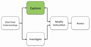
2. Distribute the Investigating Hydroelectric Dams with My World GIS handouts and investigation sheets.
3. Use an LCD projector to display My World at the front of the room.
4. Ask students to open their Hydro_Map_MW.m3vz file in My World on their computers. (If needed, have students download the file from the Student Resources Web page).
5. Model how to use the Analyze Mode to analyze the 10 most powerful dams in the USA, and analyze dam features on PA rivers (height of dam, year of completion, river name, state name, watershed, reservoir volume, and capacity).
6. Show students how to read the data table. Ask students to do task on their computers and provide guidance.
7. Instruct students to answer questions on their investigation sheets.
8. Review and discuss aloud student responses to key questions. Ask students if they have any questions about concepts covered in the lesson and respond to their questions. Have students close and not save My World GIS when they finish.
Materials Needed:
My World Handouts
(1) Investigating Hydroelectric Dams with My World GIS Teacher Guide (PDF / MS Word)
(2) Investigating Hydroelectric Dams with My World GIS Student Handout (PDF / MS Word)
(3) Investigating Hydroelectric Dams with My World GIS Investigation Sheet (PDF / MS Word)
My World GIS File
Hydro_Map_MW (M3VZ)
My World / Web GIS Assessment Information
Investigating Hydroelectric Dams with My World GIS Assessment (PDF / MS Word)
Web GIS Handouts
(1) Investigating Hydroelectric Dams with Web GIS Teacher Guide (PDF / MS Word)
(2) Investigating Hydroelectric Dams with Web GIS Student Handout (PDF / MS Word)
(3) Investigating Hydroelectric Dams with Web GIS Investigation Sheet (PDF / MS Word)
Web GIS
Teacher Resources/Content Support
Hydroelectric Energy - Print Version (PDF)
Web GIS Hydroelectric Dams Tutorial (QuickTime Video)
